
Photo by Cliff Hanna
About the Board
The San Diego City Council adopted policies in the 1960s and 1970s established and recognized Community Planning Groups (CPG) as formal mechanisms for community input in the land use decision-making processes. Torrey Pines is one of 52 communities defined by the city.
Each of the active groups work with City staff to formulate and implement the General and community plans, and to advise the Planning Commission and City Council on projects within the group's territory. As part of this function, application materials related to development projects are sent to each CPG for review. These application materials may include drawings, technical studies, and miscellaneous application materials and assessment letters. The board may suggest project changes in an iterative process before making a recommendation to the City Planning Commission. The recommendations of the planning groups are integral components of the planning process, and are highly regarded by the City Council and by staff. You may see complete descriptions on the San Diego City Planning website for Community Planning, Community Planning Groups and our profile.
The CPGs provide citizens with an opportunity for involvement in advising the City Council, the Planning Commission, and other decision-makers on development projects, general or community plan amendments, rezoning and public facilities.
Join the Board
Elections for Board members are held each March for a staggered number of years to insure a continuum of knowledge. When vacancies occur, the sitting Board may select and appoint qualified resident or local business persons for one year from those submitting applications (learn more).
Geography
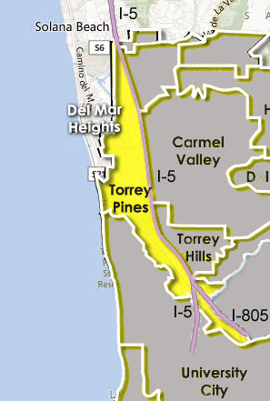 Torrey Pines is an environmentally-rich coastal community composed of 2,600 acres in the northwest corner of the City. This community of 7,800 people is bordered by the City of Del Mar and the Pacific Ocean to the west, Interstate 5 on the east and University City to the south. The community features 1,000 acres of open space, including Torrey Pine trees, lagoons, wetlands, sandstone bluffs, canyons and the Torrey Pines State Natural Reserve and the Crest Canyon Neighborhood Park and Open Space. The residential neighborhoods are centrally located in the Del Mar Heights and Del Mar Terrace areas. Within the southern part of the community is the industrial area known as Sorrento Valley. A simplified map of the community appears here and to view a more detailed map click here.
Torrey Pines Community Plan
Torrey Pines Community Plan first developed in 1975 and amended in 1996 describes the community's elements and how they are to be maintained as the living and working environment are extended. This wide ranging document includes descriptions of its topography, wildlife, zoning and land use, traffic patterns, mass transit, residential and business uses and the impact on or by neighboring communities.
The plan as amended may be viewed or downloaded here.